Skip to content
Spyder Solutions

Open it. It's live.

Two real property sites, captured by drone and published as interactive 3D twins. They run in your browser, on a phone.

  1. Drone capture
  2. Gaussian splat
  3. Interactive twin
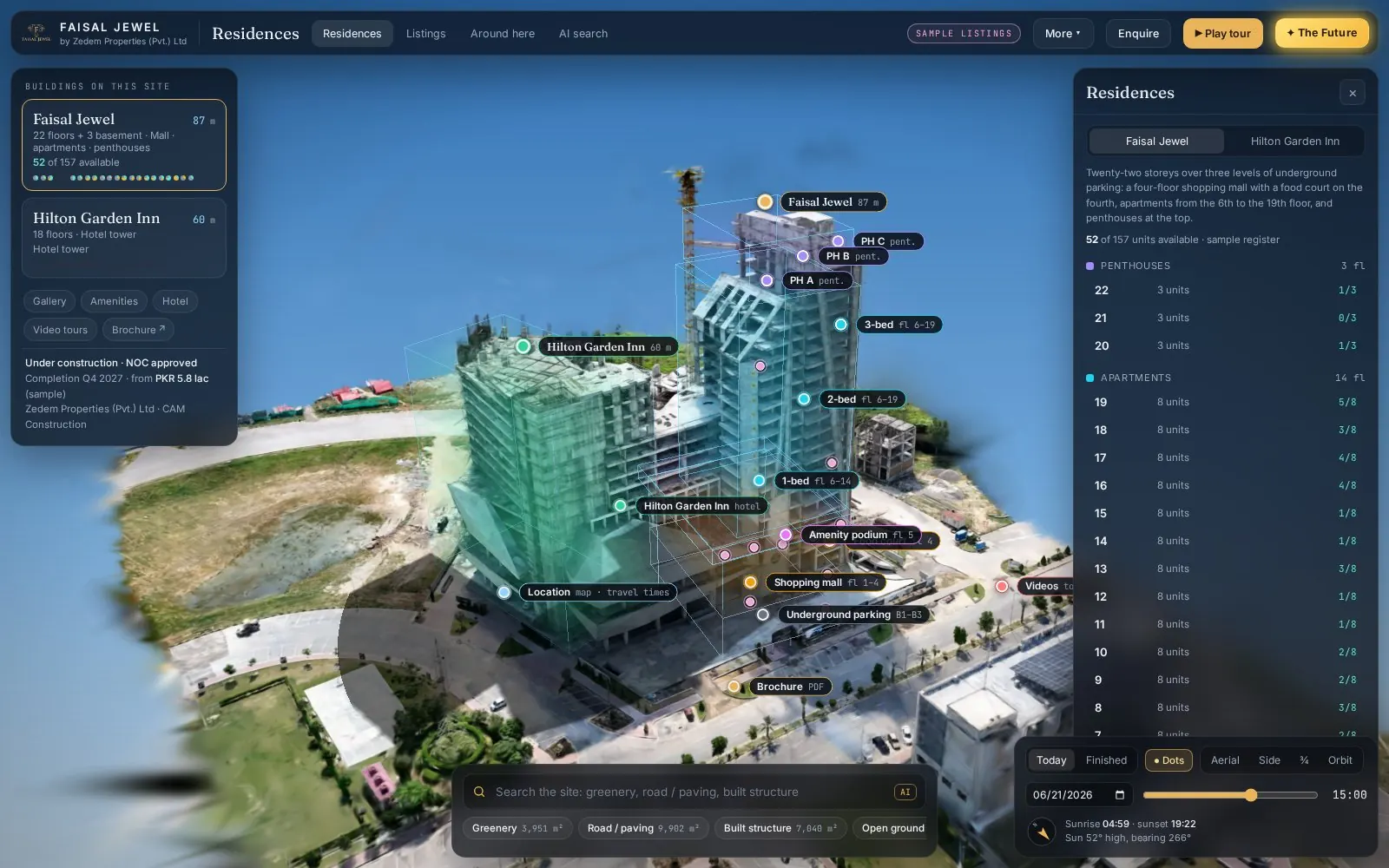
Faisal Jewel live 3D twin in the browser: the building captured by drone, with floor boxes and labels over the scene.Live · runs in the browserfaisal-jewel.pages.dev

Real estate · 3D property twin

Faisal Jewel

Drone capture to Gaussian splat to an interactive twin with floors, hotspots and sun study.

Floor boxes
Each floor drawn as a box you can select over the 3D capture.
Picture hotspots
Points in the scene open the site photo taken from that spot.
Sun study
Move the sun through the day and watch the shadows fall.
AI area search
Search for greenery, roads or built area and the matching parts light up.
Open live 3D (opens in a new tab)
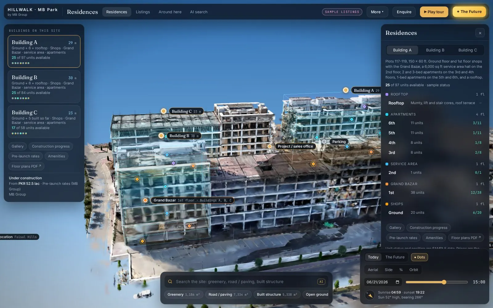
Hill Walk live 3D twin in the browser: the building captured by drone, with floor boxes and labels over the scene.Live · runs in the browserhillwalk.pages.dev

Real estate · 3D property twin

Hill Walk

Drone capture to Gaussian splat to an interactive twin with floors, hotspots and sun study.

Floor boxes
Each floor drawn as a box you can select over the 3D capture.
Picture hotspots
Points in the scene open the site photo taken from that spot.
Sun study
Move the sun through the day and watch the shadows fall.
AI area search
Search for greenery, roads or built area and the matching parts light up.
Open live 3D (opens in a new tab)

How a live twin is made.

  1. Drone capture

    Orbit and grid flights photograph the site from every side, tied to ground control.

  2. Gaussian splat

    The photos are trained into a Gaussian splat: millions of small, soft 3D points that render the site as it looks.

  3. Interactive twin

    Floors, picture hotspots, sun study and area search are fitted over the splat and published to a link that opens on a phone.

Accuracy you can check.

We report the error, not a promise. Every delivery states its method and its measured accuracy.

  1. RTK / PPK positioning

    Each drone image is positioned against a reference station.

  2. Ground control points

    Surveyed targets tie the model to real coordinates.

  3. Independent check points

    Points kept out of processing measure the true error.

  4. RMSE in every report

    You see the measured error for your site, not a brochure figure.

Accuracy report

Issued with every delivery

QA
Horizontal CRS
Stated per project
Vertical datum
Stated per project
Positioning
RTK / PPK
Ground control points
Count and layout listed
Independent check points
Kept out of processing
RMSE (x, y, z)
Reported per project
Sensor and method
Listed per delivery
Every value is measured for your site and written into the report. No brochure figures.

What you receive

  • GeoTIFF
  • LAS / LAZ
  • DEM / DSM
  • SHP / GPKG
  • IFC / OBJ
  • Dashboard link

Flown under Pakistan's Civil Unmanned Aircraft Rules 2024 with project permissions.

What lands on your desk.

Open formats your engineers and GIS staff already use, plus a web panel for everyone else.

Deliverable formats, what they contain and who uses them
FormatWhat it holds
GeoTIFFOrthomosaics and raster layers, georeferencedGIS, CAD backdrops, planning
LAS / LAZClassified point cloudsSurvey, design, volume checks
DEM / DSMBare-earth terrain and surface modelsEarthwork, drainage, flood models
SHP / GPKGVector layers: boundaries, contours, detectionsGIS and dashboards
IFC / OBJ3D models of terrain and structuresBIM and 3D design tools
Dashboard linkEvery layer and date in one web panelDecision-makers, no GIS needed

What the error number means.

RMSE is the typical difference between our model and independent check points surveyed on the ground, in the units of the data. We report it for x, y and z, with the number of check points it came from, the coordinate system and the vertical datum.

For context, two published reference points. They are standards and research results, not a Spyder guarantee: your report gives the figure measured on your site.

Flown under Pakistan's Civil Unmanned Aircraft Rules 2024 with project permissions.

A KML, a sketch on a map or a district name is enough to start. We reply by email with questions, a method and a delivery list.

33.6844° N · 73.0479° E · Pakistan · working across Pakistan and the Gulf